Client: LLOG
Subsea production systems operating under high pressure and temperature conditions are subject to thermal expansion that can lead to axial movement, buckling, and subsidence of flowlines and jumpers. Over time, this “walking” behaviour can introduce additional stress into flexible components, increasing the risk of fatigue or failure.
In the Gulf of Mexico, 2H Offshore required a reliable method to monitor subsea infrastructure across multiple drill centres in water depths of approximately 1,500 metres. Conventional inspection approaches can be time intensive, limited in coverage, and difficult to repeat consistently when monitoring subtle changes over time. Accurate baseline data and repeatable surveys were critical to supporting long-term asset integrity and avoiding unplanned downtime.
Kraken Robotics deployed its subsea LiDAR system on a work-class ROV to perform a comprehensive baseline survey of subsea structures, jumpers, and flowlines. The survey included static LiDAR scans of seven jumper structures and associated flowlines, producing a point cloud 3D dataset suitable for dimensional control and long-term comparison.
Data quality was verified in near real time during acquisition, enabling efficient offshore operations and the creation of a robust digital baseline. The resulting dataset supports repeat surveys between campaigns, depending on asset usage and operating conditions.
For flowlines subjected to higher operating temperatures and more frequent thermal cycling, material expansion, contraction, and soil–structure interaction can accelerate movement, and changes in stress distribution. Without a reliable dimensional baseline, these effects can go undetected, increasing the risk of coating damage, fatigue, and long-term integrity issues. Repeat LiDAR surveys allow engineering specialists to quantify change over time, assess trends, and make informed integrity management decisions before risks escalate.
Overlayed subsea LiDAR datasets from 2016, 2019, and 2024 reveal measurable infrastructure movement over time. These high-resolution datasets enable engineers to quantify change, assess asset behaviour, and support long-term integrity management decisions

Kraken’s subsea LiDAR enabled rapid offshore data collection, completing surveys in approximately half the time of photogrammetry-based methods. High-resolution data was captured within 24-48 hours from 12 positions, reducing vessel days and accelerating delivery without compromising measurement accuracy.

Shorter offshore campaigns and fewer survey passes significantly reduced vessel time, fuel consumption, and associated emissions. By achieving full coverage in fewer hours offshore, the LiDAR-based approach delivered measurable environmental benefits through operational efficiency rather than additional mitigation measures.

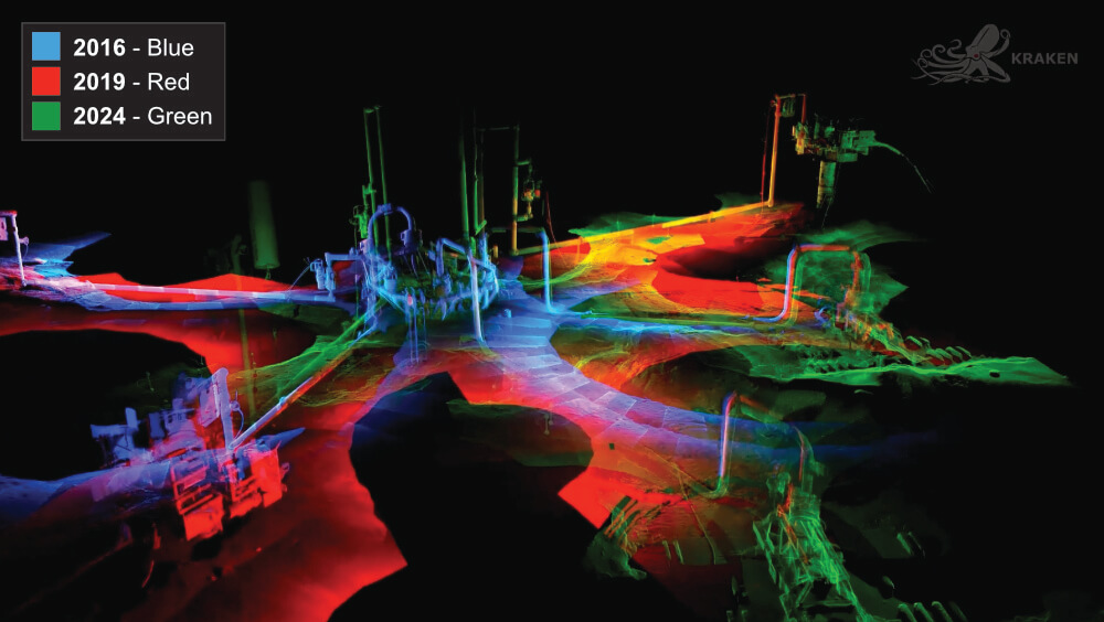
Repeatable, high-accuracy 3D datasets allowed engineers to quantify axial movement, subsidence, and seabed interaction over time. This supported early identification of change, smarter remediation planning, and predictive maintenance decisions - helping reduce risk, avoid unplanned downtime, and extend asset life.