Sub-Seabed
Boulder Survey

Symra & Solveig Oil and Gas Fields

Client: Deep Ocean / AkerBP
Location: Norway

Kraken’s Sub-Bottom Imager penetrates the seabed with 3D synthetic aperture sonar, delivering critical data on the location and size of buried boulders that could impact the design and installation of offshore oil and gas facilities.

Challenge

Kraken Robotics was commissioned by Deep Ocean, on behalf of AkerBP, to perform a sub-seabed survey at the Symra and Solveig oil and gas fields in the central North Sea. The survey was required to determine the best location for future oil and gas structure foundations, which can be impacted by buried boulders. In the early stages of planning for an offshore oil and gas installation, it’s most efficient to understand the geology and lithology of the sub-seabed before beginning installation. If boulders are found, the site can be relocated early in the process, avoiding significant costs and delays. Kraken was instructed to survey the area and identify buried boulders greater than 0.2 meters in size

Case Study Image SBI v1

Solution

Kraken Robotics utilized its Sub-Bottom Imager (SBI) mounted on the base of a Work-Class Remotely Operated Vehicle (WROV) to perform the sub-seabed survey.

This advanced system provided high-resolution 3D acoustic imaging, which allowed for precise detection and mapping of acoustic anomalies indicating potential buried boulders.

Survey operations were performed at three sites, covering a total of 42.9 kilometers at a depth of about 230 meters. A total of 124 survey lines were acquired over five days.

Kraken Robotics was commissioned by Deep Ocean, on behalf of AkerBP, to perform a sub-seabed survey at the Symra and Solveig oil and gas fields in the central North Sea. The survey was required to determine the best location for future oil and gas structure foundations, which can be impacted by buried boulders. In the early stages of planning for an offshore oil and gas installation, it’s most efficient to understand the geology and lithology of the sub-seabed before beginning installation. If boulders are found, the site can be relocated early in the process, avoiding significant costs and delays. Kraken was instructed to survey the area and identify buried boulders greater than 0.2 meters in size
Symra and Solveig Figure 1 Plan View

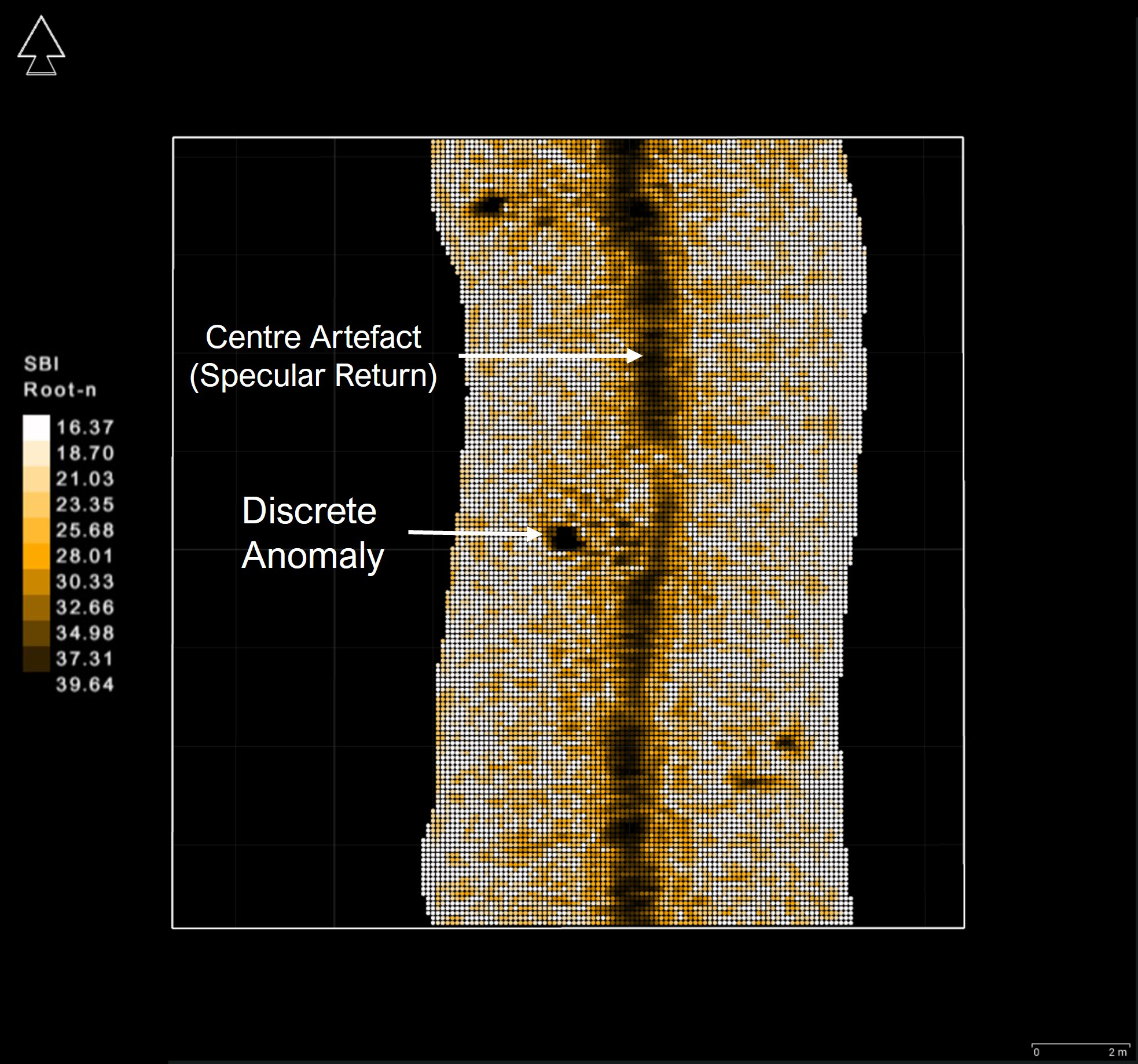
Figure 1 - Plan view of the SBI data showing an identified discrete anomaly

Symra and Solveig Figure 2 Profile View

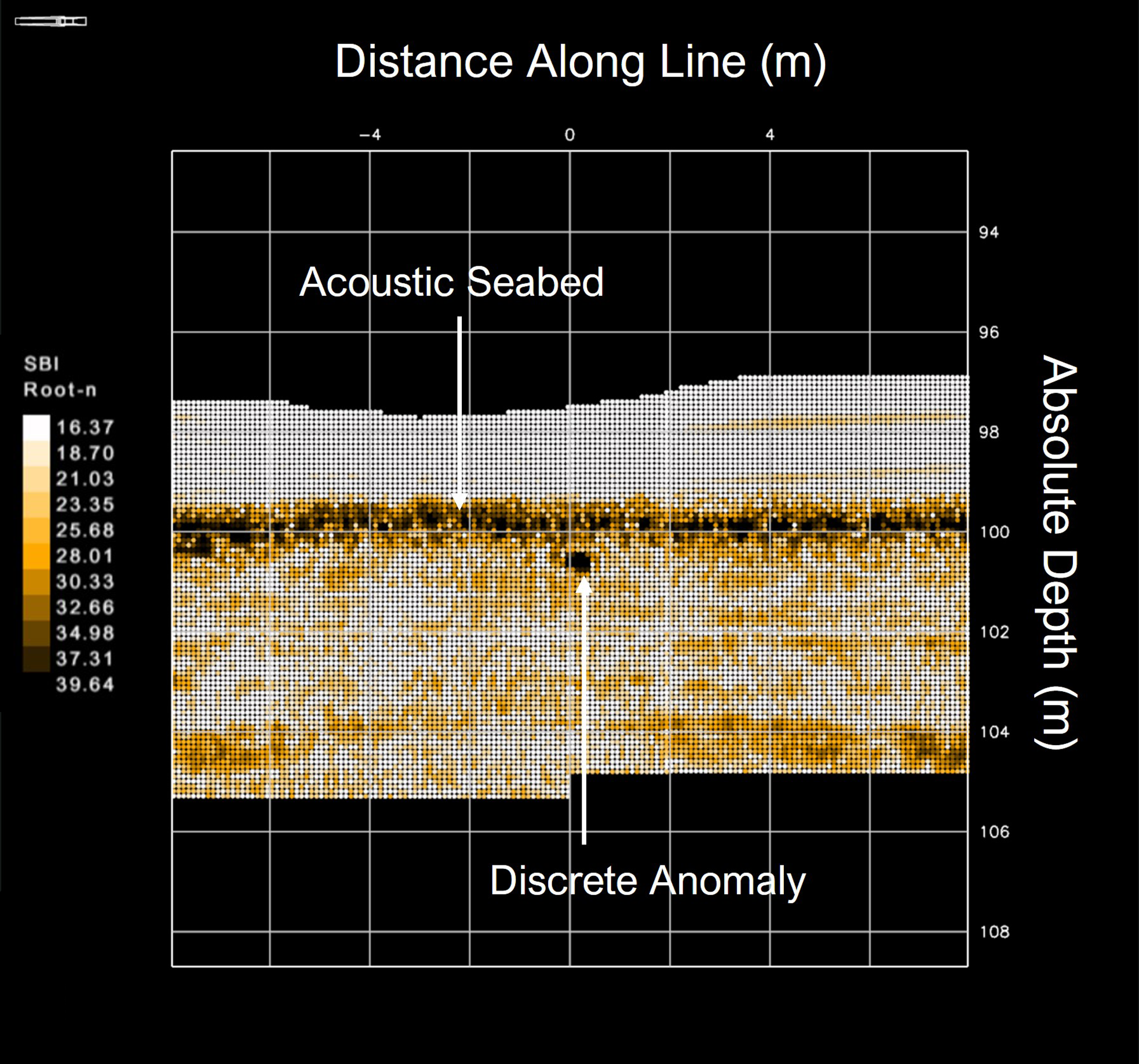
Figure 2 - Profile view of the SBI data showing an identified discrete anomaly

Results

Results Matter Dark

Efficient & Accurate Surveys

Kraken provided Deep Ocean with a discrete anomaly listing for each survey area, detailing the location, depth, length and width of the anomalies as well as the shape and suggested interpretation (often buried boulders).

Quality and Excellence Dark

Operational Assurance

Kraken also identified and interpreted lithological boundaries which could hinder infrastructure emplacement, delivering isopach (depth) maps to the client. Seg-Y files were also provided so further analysis could be undertaken by the client.

Retirement Savings Dark

Cost & Schedule Savings

Using Kraken’s SBI data, Deep Ocean was able to quickly determine the best location for the oil and gas installation, ensuring the project could progress on schedule and within budgets.

Case Studies

Depth of Burial Survey for Inter-Array Cables

Borkum Riffgrund 3 Offshore Windfarm

SBI WEB5expanded scaled
SBI Skid Kraken NB

Sub-Seabed Boulder Survey

Symra and Solveig Oil and Gas Fields

Sub-Seabed Boulder Survey

Baltyk II & III Offshore Windfarms

IMG 5641 scaled
Kraken AC Leo v1 scaled

Sub-Seabed Cobble and Boulder Survey

Gennaker Offshore Substation (OSS)

For Customer Support or to Speak to One of Our Team